GPT-6.1 Sol is the new king in this lawn-mapping head-to-head.
We gave Sol and Astra the same residential aerial, parcel context, mapping tools, medium reasoning setting and animated drawing. Sol finished faster, at a much lower reported model cost, while drawing a visibly similar lawn outline.
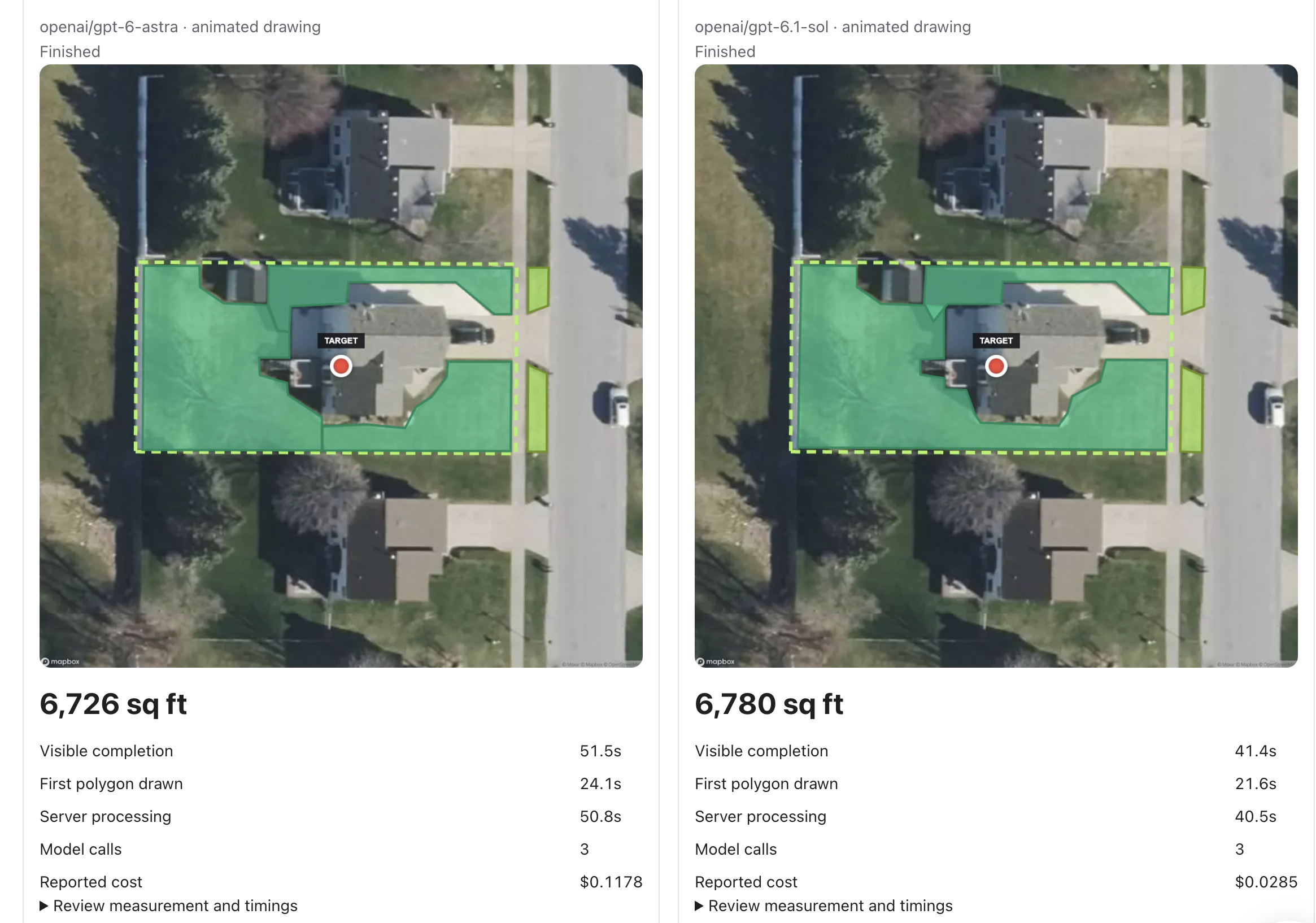
Same property. Two live maps.
Both models completed the measurement with three model calls. Sol started drawing its first polygon at 21.6 seconds, 2.5 seconds before Astra. It reached visible completion 10.1 seconds earlier. Its reported model cost was $0.0285, compared with Astra’s $0.1178.
| Measure | GPT-6 Astra | GPT-6.1 Sol |
|---|---|---|
| Estimated lawn | 6,726 sq ft | 6,780 sq ft |
| Visible completion | 51.5 s | 41.4 s |
| First polygon drawn | 24.1 s | 21.6 s |
| Server processing | 50.8 s | 40.5 s |
| Model calls | 3 | 3 |
| Reported model cost | $0.1178 | $0.0285 |
The total square-foot estimates differed by 54 sq ft, about 0.8% of Astra’s estimate. The two maps look close overall; inspect the outlines in the image above to see where the models differ around the house and side lawn.
A strong challenger, with one test behind it.
Sol won this run on speed and reported model cost. Similar square-foot totals do not prove that either outline is accurate: a missed lawn patch and an included non-lawn patch can cancel in the total. This run has no independently surveyed or user-corrected reference outline, so we cannot assign either model an accuracy score from it.
Both requests ran concurrently; provider load, caching and network conditions can affect timing. The reported costs reflect model usage in this run, not imagery, parcel data, storage or all of OpenLawn’s operating costs. We would repeat this comparison across different properties and score the outlines against reviewed references before changing the production default.
What was held constant.
This was OpenLawn Color Playground’s saved head-to-head run from September 29, 2026 at 8:21 p.m. Eastern, on one Michigan residential property. Both sides used Mapbox satellite imagery framed to the same property, whole-yard scope, the same mapping workflow and animated drawing. Each requested medium reasoning. The model IDs were openai/gpt-6-astra and openai/gpt-6.1-sol.
The image is the unaltered screenshot of the completed comparison. The private experiment archive retains the source aerial, results, event replay, timing data and recording. We omit the street address here.
Measure the lawn. Review the map.
After this case study, GPT-6.1 Sol became the default in Agent View. Users can remeasure a completed Sol result with Astra for another credit and compare both saved maps. Every aerial measurement needs a human check before it drives a quote.
Try OpenLawn free ↗Read our broader model benchmark ↗